Singapore’s young population
The following maps are the chloropleth maps our team generated for the five years we considered.
Singapore’s young population in 2014
For the distribution of young people in 2014, we found that Tampines East and Woodlands East have the highest number of young people with 13975 and 17640 respectively. We also observe that the extreme West, East and North areas of Singapore are the most highly populated with young people while there are not many young people living in the Southern area of Singapore.
Singapore’s young population in 2015
In 2015, we observed that Tampines East and Woodlands East continue to be the areas with the highest number of young people in the area. Punggol has the biggest increase in young people of 3150 compared to 2014 while Teck Whye, Peng Siang and Yishun South all faced a decrease in young population compared to 2014.
Singapore’s young population in 2017
In 2017, Punggol Field, Anchorvale and Kaki Bukit all saw an increase in young people while the other areas did not see much changes. Overall, not much significant changes were observed in the young population living around Singapore and we still observe the trend of many young people in Singapore living in the extreme West, East and North regions.
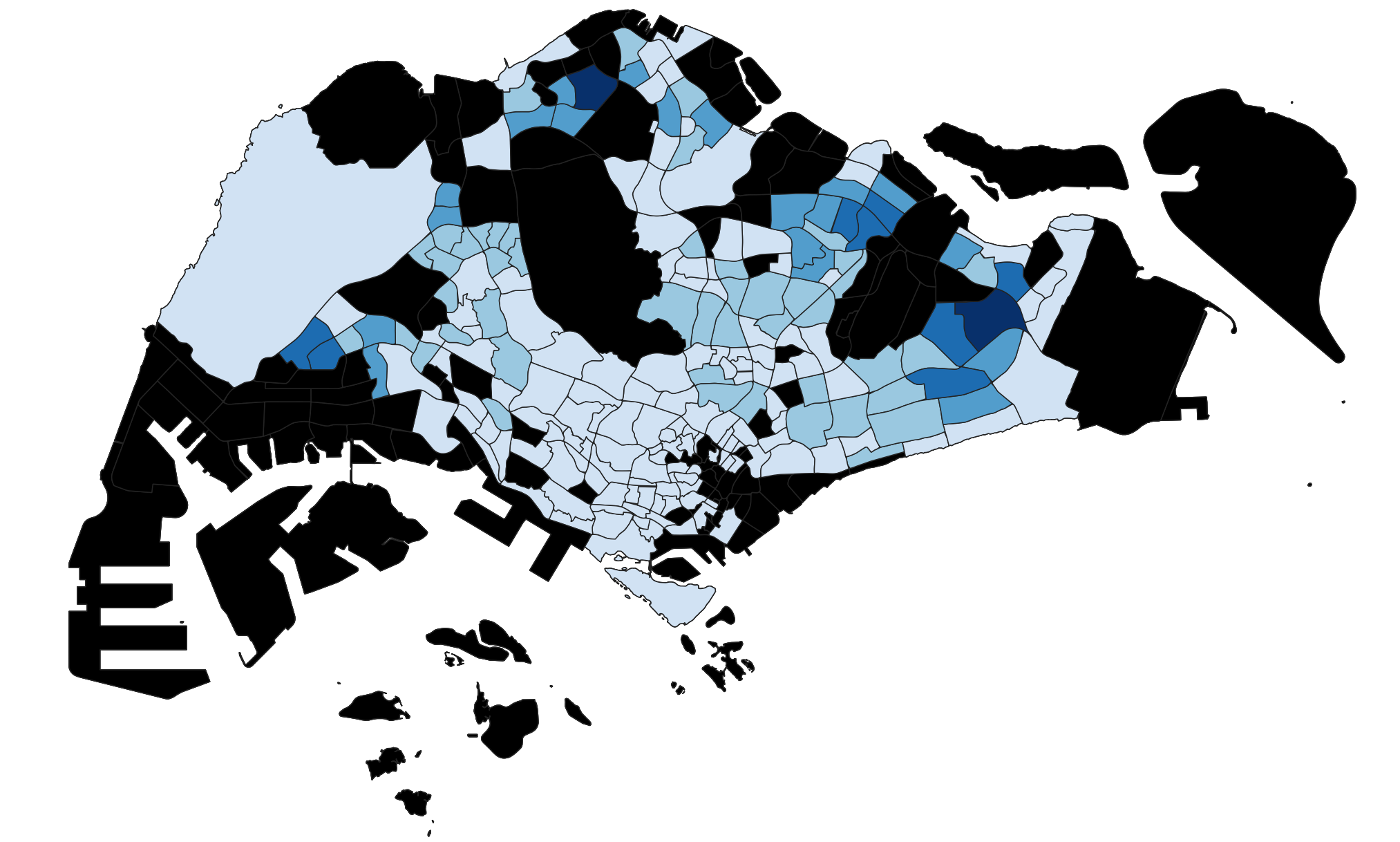
Singapore’s young population in 2019
In 2019, Fernvale and Seletar saw an increase in the number of young people while other areas did not see much changes. However, this change was not very significant and the distribution of young across Singapore is similar to that of 2017.
In 2017, there was no change in the number of primary schools and pre-tertiary institutions, while there were 6 pairs of secondary schools that merged. The lack of change in distribution of young people after this merger took place implies that prospective secondary school students are not greatly affected by the decrease in accessibility.
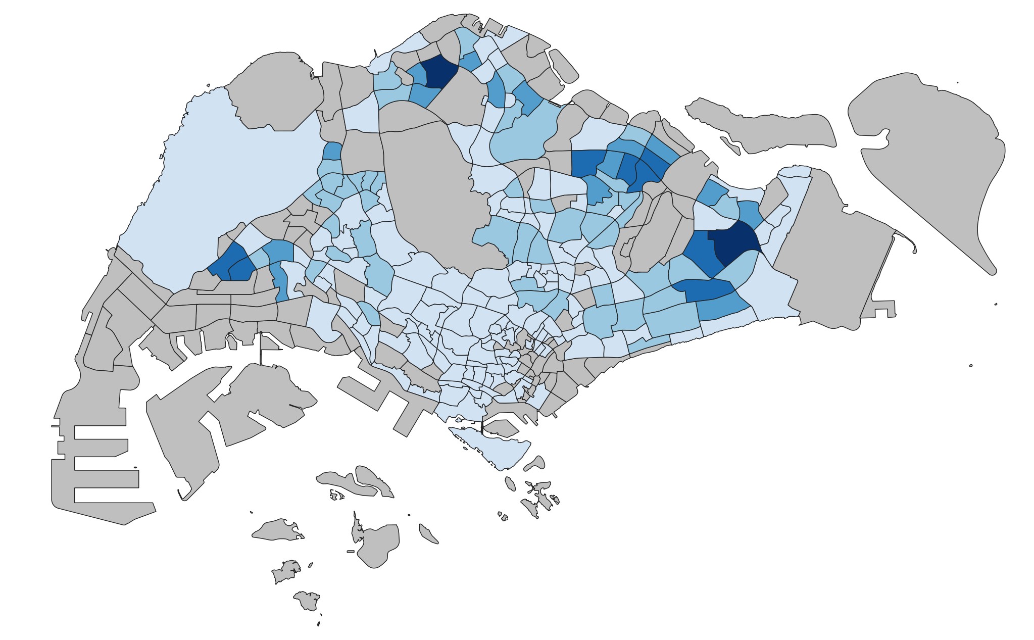
Singapore’s young population in 2020
In 2020, there was an increase in the number of young people in Keat Hong, while there was a decrease in Hillview, Yuhua East and Pasir Ris West. Other than that, there is no significant observable change in the distribution of young based on the choropleth maps. There may be changes that are not captured visually as the new numbers may still fall within the same band. As such, our group decided to calculate the difference in the number of young people between selected years.
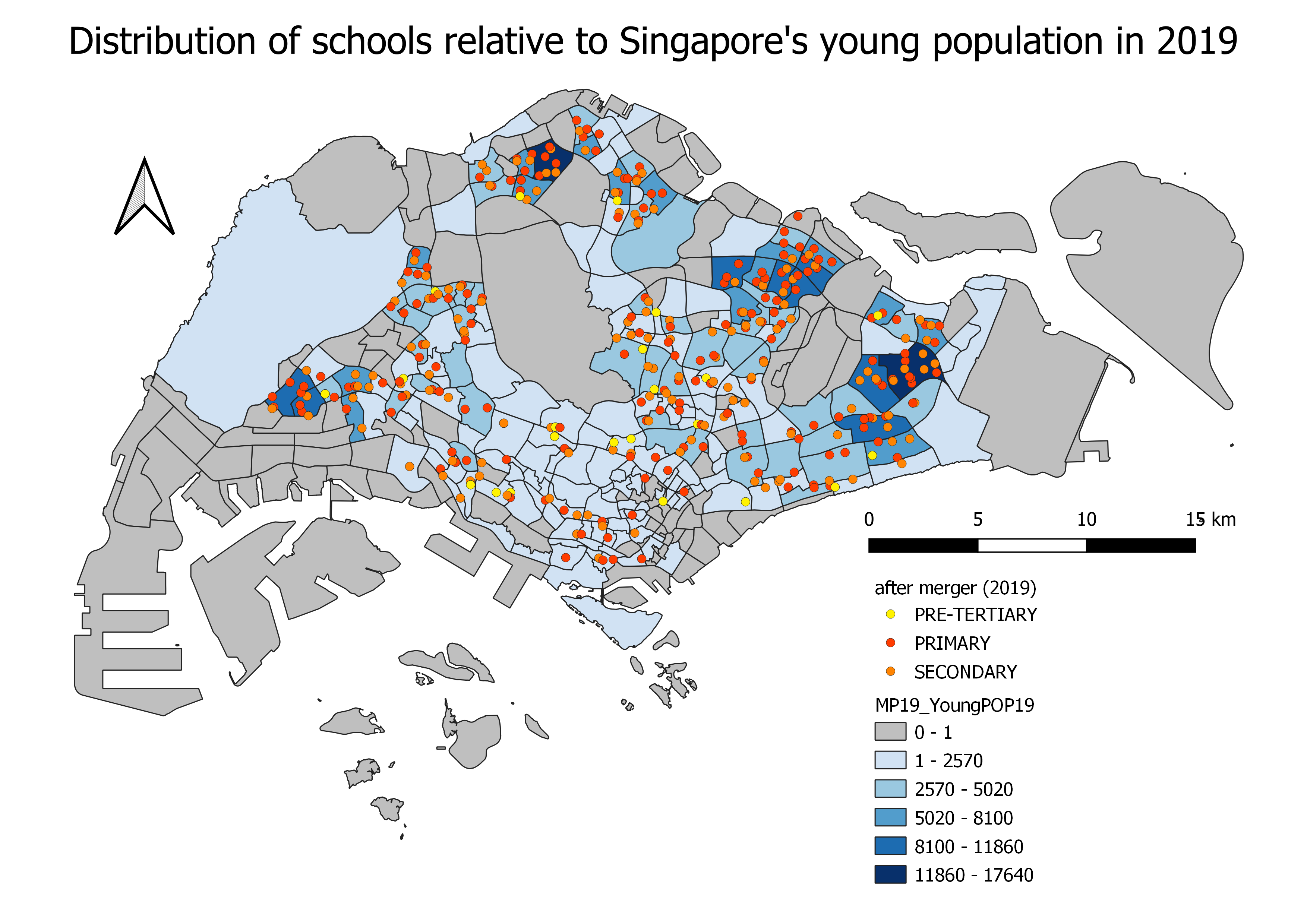
Distribution of schools relative to Singapore’s young population
On the whole, primary and secondary schools are spread across Singapore, but subzones in the highest band (with 118960-17640 young people) have minimally one primary and secondary school each, within the area of the subzone. They generally also have more schools than in other subzones.
Most of the pre-tertiary schools are clustered towards the central region of Singapore, but it does not have a direct correlation to the distribution of young. However, there is at least one pre-tertiary school in each region (e.g. West, North, East).
Changes in Singapore’s young population through the years
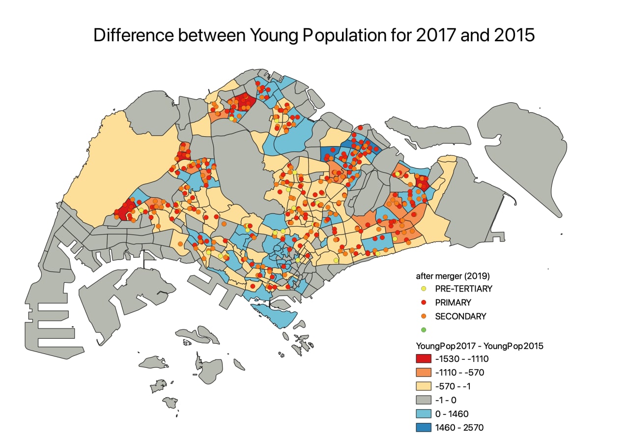
As it was difficult to visualise the changes in population by looking at the chloropleth maps, our team plotted new maps to visualise the difference in population for each pair of consecutive years. We classified the values such that shades of red reflect an increase in population (e.g POP19 > POP20) while shades of blue reflect a decrease (e.g POP19 < POP20). Grey indicates that there was no change in population during the two years.
Our analysis is as follows.
Comparing 2015 and 2017 Young Population
Choa Chu Kang, Yunnan, Pasir Ris Drive and Woodlands East all faced an increase in the number of young people. We can also see that these areas have many primary and secondary schools around which make them more accessible for residents living in the area, resulting in the increase in young people.
Fernvale, Punggol and Waterway East have a decrease in young people living in the area. However, these areas do not have that many schools densely populated in the area as compared to the areas with an increase in young people. Hence, these areas may not be that accessible to the schools and resulted in a decrease in young people living there.
Comparing 2019 and 2020 Young Population
.png)
From 2019 to 2020, subzones that experienced an increase in the number of young people include Fernvale, Seletar and Brickworks.
On the other hand, examples of subzones that faced a decrease in the number of young people are Jurong West, Choa Chu Kang North, Midview and Bedok North.
In the East, there were two pairs of primary schools that were merged in 2019 – Casuarina Primary School and Loyang Primary School, and White Sands Primary School and Coral Primary School. Although there is a subzone with a large number of young people (Tampines North – dark blue), the neighbouring subzones (Tampines East and Pasir Ris Drive – red) had experienced a decrease in the number of young people. Hence, the decision to merge schools in this area seems to be justifiable as the demand for primary school education is likely to have decreased.
Accessibility maps of Singapore’s educational institutions
Primary Schools

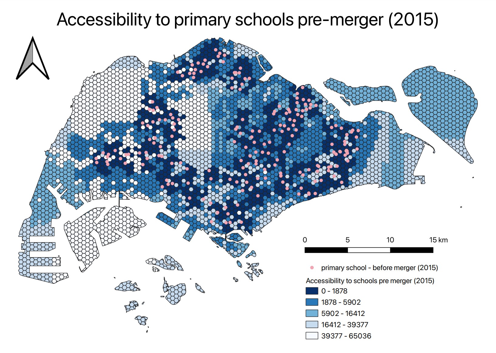
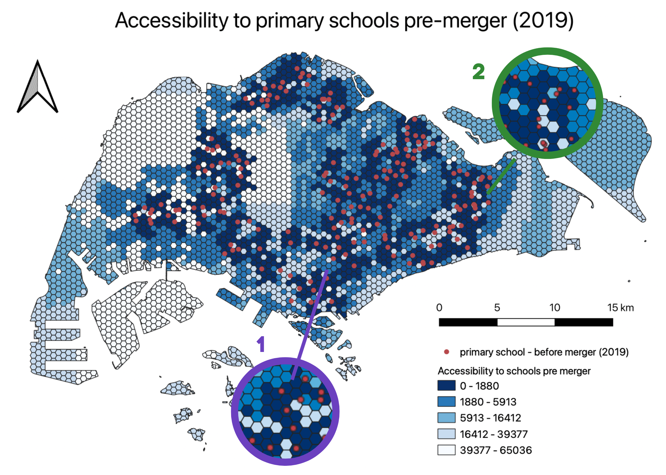
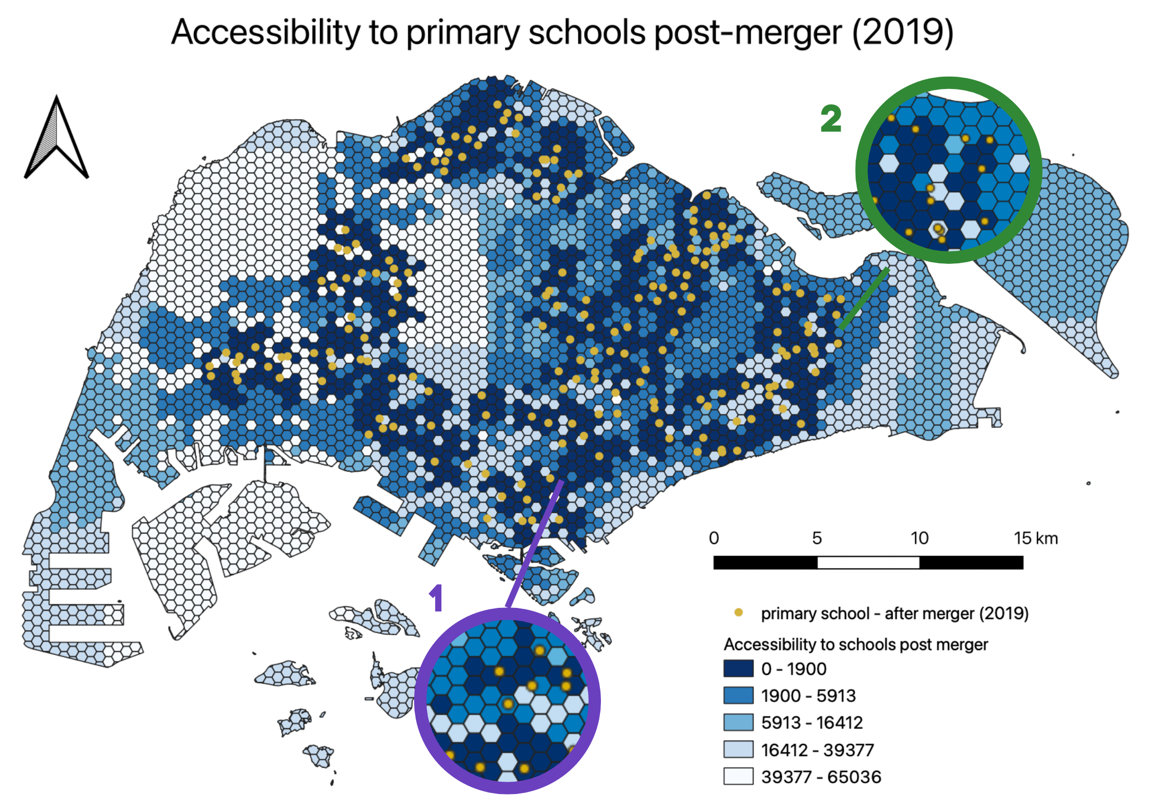
Amongst the years we analysed, the merger of primary schools in 2019 resulted in the greatest change in accessibility, with 7 pairs of primary schools being merged, whereas only 4 pairs of primary schools were merged in 2015. No primary schools were merged in 2017. Hence, we will be focusing our analysis on the 2019 merger. Even in 2019, the change in accessibility was not very significant as we realised that the primary schools that were merged together were usually done for schools in close proximity. The quantile values for shortest distance are also mostly unchanged, with the only exception being the first band.
In the highlighted Area 1, Balestier Hill Primary School and Bendemeer Primary School were merged together. With this merger, the accessibility in the surrounding areas decreased slightly. One example of how the shortest distance changed, was from 1628m to 2479m.
In the highlighted Area 2, two pairs of schools were merged — Casuarina Primary School and Loyang Primary School, and White Sands Primary School and Coral Primary School. Similarly, even though two pairs of schools were merged, the accessibility was not greatly affected as the schools were all in close proximity to one another.
Overall, although the accessibility to primary schools decreased, the equity of access to primary schools was not greatly affected, due to the government choosing to merge schools that were already in close proximity. Additionally, there are a large number of primary schools, so each merger would not have as significant an impact on accessibility as compared to pre-tertiary institutions.
Secondary Schools

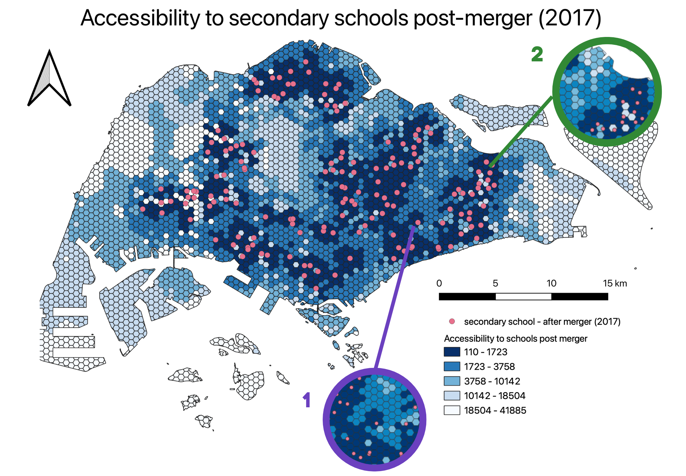
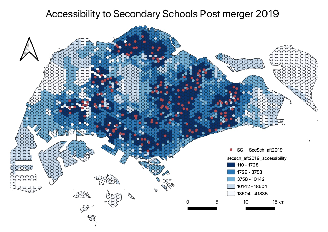
The merger of 6 pairs of secondary schools in 2017 resulted in the greatest changes in accessibility to people. Overall, there was a decrease in accessibility as the areas that used to be of short distances of range 110-1644 from a school saw an increase in distance to the range 1723-3758.
In the highlighted Area 1, the merger of Damai Secondary School at Bedok and Manjusri Secondary School at Ubi has resulted in a larger decrease in accessibility as these schools are around the same area. As a result, residents living in the area used to have 3 schools near them but after the closure of the 2 schools, there is only 1 school nearby. Hence, secondary schools are not as accessible as before for these residents as seen in the shortest distance increasing from 1196m to 1951m.
In the highlighted Area 2, the merger of Siglap Secondary School at Pasir Ris has decreased accessibility to secondary schools for those living in the area. As seen in the diagram, the presence of Siglap Secondary School made it accessible for more residents as the area of high accessibility is larger. However, after the merger, the residents in this area. The shortest distance to the nearest school of the area where Siglap Secondary School is located increased from 110m to 2522m.
Hence, while there is an overall decrease in accessibility to secondary schools from the mergers, the impact is not extremely significant to the point where equity to access is compromised. This is due to the large number of secondary schools that are already present in Singapore and located in many different regions in Singapore. However, this is with the assumption that secondary school students travel to school by public transport and/or by foot which may not apply for everyone. Furthermore, certain people and families may prefer to go to more prestigious schools which are mostly located in the central area and is considered inaccessible to certain group of people.
Pre-tertiary Institutions
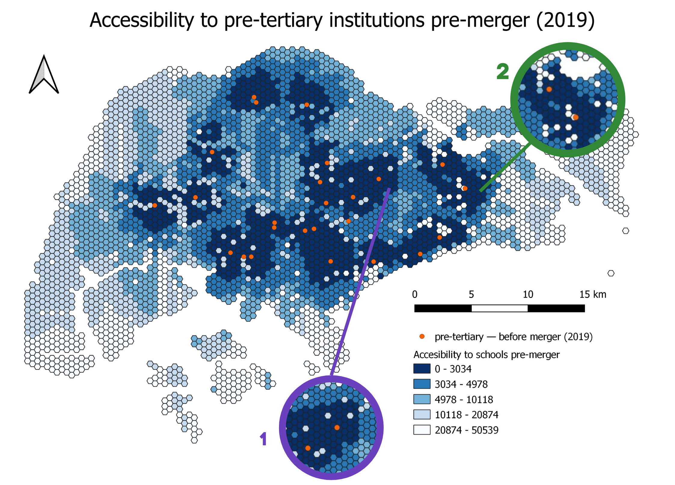
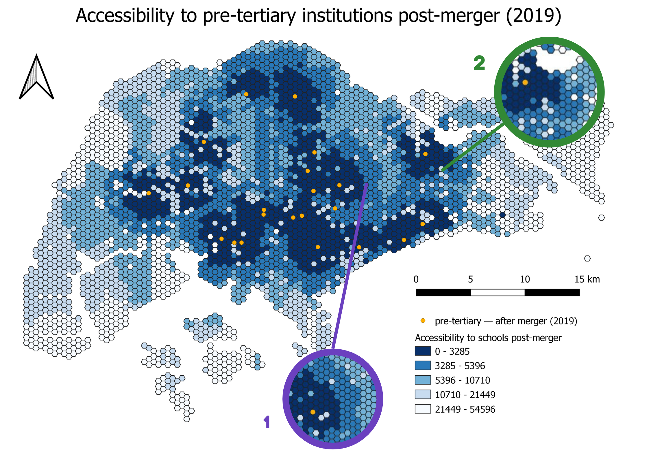
Out of the three education levels our team analysed, mergers of pre-tertiary instituitions had the greatest impact on accessibility. This is likely because there were originally not many Junior Colleges (JC) and there was a considerable distance between the various pre-tertiary institutions before merger, hence this merger had a greater decrease in accessibility compared to primary and secondary schools. While our study included Polytechnics, International Baccalaureate programs, and other schools, only 4 pairs of JC, each in different regions of Singapore, were merged as part of the College Rejuvenation Programme by the government. This was in response to decreasing enrollment rates for JC.
In the highlighted Area 1, Serangoon Junior College merged with Anderson Junior College, resulting in both schools moving to Anderson Junior College’s original campus and the closure of Serangoon Junior College’s existing campus. This decreased accessibility for students living in the Hougang subzone. This can be seen as the shortest distance to the nearest JC for students living in Hougang increased from 3034 to 5396.
In the highlighted Area 2, Tampines Junior College merged with Meridian Junior College, resulting in both schools moving to Meridian Junior College’s original campus and the closure of Tampines Junior College’s existing campus. This decreased accessibility for students living in the Tampines subzone as the shortest distance to the nearest JC for students living in Tampines increased from the range 3034 to 5396.
To sum up, the mergers of pre-tertiary institutions, specifically Junior Colleges, definitely brought about decreased accessibility for students as there were already a limited number of JC to start with. However, in the grand scheme of things, the mergers were necessary given the decreasing enrollment rates which were predicted to fall to as low as 200 to 300 students. Hence, the mergers were needed to prevent a waste of resources and inefficient manpower allocation.